
Hope for Today Outreach (HTO) provides basic essentials to the poor, the needy, and underprivileged families in need in the Caribbean nation of Haiti. Our ultimate objective is to contribute to the country’s long-term and sustaining development–both in the material and spiritual sense. At the moment, we are serving in Corail, a municipal of the town of Port-Margot.
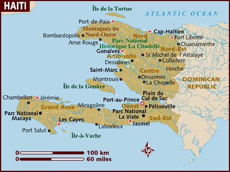
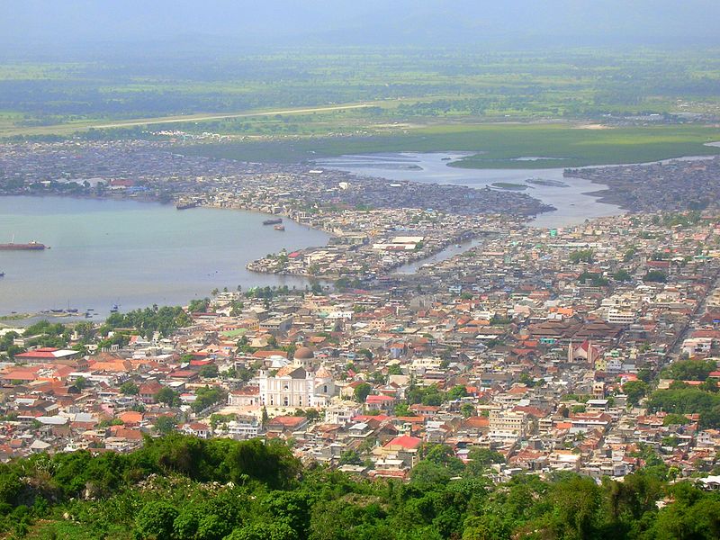
Port-Margot is a commune in the Borgne Arrondissement, in the Nord Department of Haiti. Based on the 2013 census, its population is about 100,000 people. The rural town of Port-Margot is less than two hours (if you drive by car) away from the city of Cap-Haitien— a major port area and the second largest city of Haiti. The town of Port-Margot is located between Limbe and Borgne. Like other parts of the country, Haitian Creole is spoken by the majority of the population; the French language is spoken only by the educated few. The three major practicing faiths in the region are Roman Catholicism, Protestant Christianity, and Vodou. The oldest Church in Port-Margot, Sainte Marguerite Parish, was founded in 1711.
Most of the people who live in Port-Margot and the surrounding areas such as Corail, Bayeux, etc. are farmers and illiterate. It is estimated that more than 65 % of the population is unable to read. The complementary information below is provided by the Organization for the Development of Port-Margot (ODEP):
“Port-Margot, city founded by Bertrand d’Orgeron in 1625, is located 35 km from the city of Cap Haitian, the principal city in the Nord department of Haiti. Historically, it was the first French establishment of Saint Domingue with the “boucaniers” and “filibustiers” around 1630. It was a flourishing colonial region. The municipality is composed of two big neighborhoods: Petit Bourg and Bayeux, and six sections, namely Bas-Petit Borgne, Haut Petit Borgne, Bas-Quartier, Bras Gauche, Grande Plaine and Corail.
Today, Port-Margot is home to about 100, 000 Haitians with mostly all Faith representatives (Catholicism, Adventist, Wesleyan, Baptist, Methodist….). There are several Kindergarten schools, elementary and high schools and a parish hall for social events; the Dominique Batraville library has severely limited services; a few health centers offer services, yet they are limited due to a lack of resources. Transportation is underdeveloped but is worth the effort as Port-Margot is one of the locations of the most captivating beaches in the country. Business is also underdeveloped. Most state institutions are present: the tax collector’s office, the town hall, two courthouses, the civil registry office, the Communal agrarian office, the Haitian National Police, and the Regional Board of education.
With a topography characterized by hilly ground in the east and west, Port-Margot is a predominantly agrarian region where seasonal agriculture and small-scale fishing are used. The fields were once green and production had increased considerably. Each parcel of land was cultivated according to the needs of the community, and the surplus sold to the big cities. Unfortunately, what appeared to be a terrestrial paradise gradually changed. The lands were devalued due to deforestation. Approximately a quarter of its mountains are still green and wet but we observe less production of several precious commodities like coffee beans, cocoa and other food plants. The river frequently changes its bed. During the drought season, it has only a thin filament of water, but in the rainy season, it terrorizes the whole region along its path. The migration towards the metropolitan cities or Dominican Republic, unemployment, intensification of a lack of basic necessities (drinking water, electricity, public services, communications, etc.) and lack of healthcare has contributed even further to the economic recession of the region…
Despite the problems, Port-Margot still maintains its charm, with an average temperature of 29 degree Celsius, modern recently-built houses and an abundance of activities to satisfy almost everyone. Chouchou Bay, is known for its white sand and vast coral reef that can be reached and appreciated by divers and enthusiasts about 10 to 15 meters from the surface of the water. It is also surrounded by an array of luscious mountains. In this slice of paradise, it is only you, your feelings, and imagination. Whether you choose to come by boat, car or on horseback, you will find it hard to leave this dreamlike paradise. It’s also worth mentioning other beautiful beaches: Coup de Sable or Cabaret, Pass Kannot, Coco. It is awesome to visit Basen Waka in Novion or Djambou’s fall in Bas Petit Borgne for a cool shower. One can also enjoy a romantic sunset at Morne Coplan, and camping site and family picnics at l’Ilet. The coastal municipality also has its share of annual beach festivals. Every 20th of July, Port-Margot residents, visitors, and the entire neighborhood celebrate the feast of Sainte Marguerite, in honor of the town’s patron saint. Every 4th of September, we celebrate the feast of Saint Bertin in Petit Bourg; on June 13th we celebrate the feast of Saint Antoine de Pardoue in Aria, and on August 24th we celebrate the feast of Saint Louis in Novion, near Chouchou Bay.”
We also reference this short essay by the Organization for the Development of Port-Margot (ODEP).
“Port-Margot past and present”
By Staff
Organization for the Development of Port-Margot (ODEP)
Origin

The origin of the name “Port-Margot” is unknown to us. Port-Margot was the first French settlement in Saint Domingue and it already bore this name when the buccaneers came to settle in. As of 1630, the French, chased out of the island of Saint Christophe, had joined forces with the Pirates from Ile de la Tortue to venture toward the coast of Port-Margot to establish dins, i.e. temporary establishments where they roasted meats or preserved them by smoking them.
Limits
The boundaries of the town of Port-Margot are: in the Northern side the sea, in the Eastern side the town of Limbé, in the South the town of Pilate, and in the West the town of Borgne.
A few hundred meters from the eastern side of Port-Margot’s cove, towards the North-West side is the refuge aka. The islet is located a few cables’ length away from the Rocher d’Orgeron, which the pirates had used as a prison.
The municipality of Port-Margot is divided into six sections, the last five of which are only slopes of mountains or just mountains, they are:
Bas-Quartier – Grande Plaine – Bas Petit-Borgne – Corail – Haut Petit Borgne – Bras gauche
River

The Port-Margot River traverses the commune vertically. It begins from the hills of Margot, then snakes its way through Petit Bourg, Grand Bourg and ends up at the sea just East of Bayeux.
On its way to the sea, it connects with several other brooks that add to its strength. They are the river of Petit Bourg on the left; the river of Corail connected on the right by that of Corneille, and the river of Petit Borgne that merges upstream from that of Bayeux.
The Port-Margot river is on a flood zone. During the drought season it has only a thin filament of water, but in the rainy season, it terrorizes the whole region along its path.
Major roads
The municipality of Port-Margot is located along the northern coasts of Haiti approximately 35 km (22 miles) from the city of the Cap-Haitian via a road that goes through the town of Limbé, then national highway No. 1. It is connected to the town of Borgne, 20 km (12 miles) away, via a road that passes through Bayeux and connects with the town of Port-de-Paix.
Fertility of the municipality
 The municipality is one of the most fertile in the northern region of Haiti due to its many rivers. Approximately a quarter of its mountains is still green and wet and produces several precious commodities like coffee beans, cocoa and other food plants. The rainy season starts in August up to including January.
Economic situation
Around 1900-1980 unemployment was almost nonexistent. The fields were green and production had increased considerably. Each parcel of land was cultivated according to the needs of the community, and the surplus sold to the big cities. Unfortunately, what seemed to be the terrestrial paradise gradually and completely changed. The lands were devalued due to deforestation; the agrarian layer was diminishing daily and moving towards the sea, thus reducing cultivable space. Moreover, the river frequent changes of its bed caused enormous losses to the population. Adding insult to injury, the migration towards the metropolitan cities, unemployment, and lack of healthcare had contributed even more to the economic recession of the area.
Entertainment
In spite of these difficulties, Port-Margot still keeps its charm and abounds in activities that satisfy almost everyone. Its beaches are among the most beautiful ones in the country: Chouchou Bay with gilded white sand, Coup de Sable or Cabaret, Pas Kannot, Coco. It’s also worth mentioning Basen Waka in Novion on the Thibaud residence. One can also enjoy a romantic sunset at Morne Coplan, a camping site, and action-packed family picnics at l’Ilet.”
Water and Sanitation in Haiti
Source: Banco Mundial LAC

*Click on the link above to know more about each respective place.
Haiti: An Overview

| Population | 10.3 | 2013 |
| GDP | $8.4 | 2013 |
| GDP growth | 4.3% | 2013 |
| Inflation | 4.6% | 2014 |
| More Data » | ||
“Five years after the magnitude 7.0 earthquake struck Haiti on January 12, 2010, Haiti has moved from recovery to longer term development as it continues to improve infrastructure and strengthen institutions, work toward increasing access to education, health and other services, and stimulate investment.
In spite of the enormity of the task, much has been done by Haitians and the Haitian Government, in partnership with CSOs, the private sector, and the international community.
- Of the 1.5 million internally displaced people, more than 1.4 million have left the camps and relocated. Reconstruction programs are repairing and building safer housing and upgrading neighborhood infrastructure.
- Haitians children have benefitted from better access to primary education, where participation rates of school-age children rose from 78 to 90 percent. However, the quality of education and learning remains a challenge. Only one third of all children aged 14 are in the appropriate grade for their age.
- Haiti has made progress in controlling the cholera epidemic since the 2010 outbreak with reported case numbers decreasing from a monthly average of more than 35,000 in 2011, to about 2,200 cases per month in 2014. However, cholera continues to be a threat and water borne diseases are among the leading causes of infant mortality in the country.
- The government has also taken action to reduce extreme poverty in Haiti by launching several social safety initiatives for the poorest. However, sustainability, targeting, and coverage remain significant challenges. Only 8 percent of the Haitian population received noncontributory social assistance benefits in 2012, such as scholarships, food aid, and other transfers.
Nevertheless, much remains to be done to reduce poverty and improve the wellbeing of Haitians.
POLITICAL SITUATION
In recent years, the political situation had been relatively stable. Having been elected in 2011, a year after the earthquake of 2010, President Michel Martelly has less than one year left on his term. However political tension due to delays in holding Parliamentary and Municipal elections led to the resignation of former Prime Minister Lamothe in December 2014, who had led the Government for over two and a half years. Since January 2015, most Parliamentarians terms have expired and, without the possibility of quorum, parliament is no longer functioning. As a result, President Martelly is left to rule the country by decree with an interim Government.
However, with the publication of the electoral calendar for presidential, parliamentary, municipal elections, starting in August 2015 and ending at the beginning of 2016, the crisis appears to be receding. According to the UN Secretary-General’s latest report on the UN Stabilization Mission in Haiti, the country has made some “measurable gains towards the holding of long-overdue elections by the end of 2015, despite the lingering ‘uncertainty’ caused by the absence of a functioning Parliament.” Key political parties have registered to participate in the process.
ECONOMY
The Haitian economy has been recovering since the earthquake. Growth has been modest, but macroeconomic stability has been maintained and inflation generally controlled. This was achieved, despite an unfavorable international economic environment, droughts and pests drastically reducing agricultural production, and repeated hurricanes and tropical storms, including Hurricanes Isaac and Sandy.
Economic growth is estimated at 2.7 percent in fiscal year 2014, down from the 4.3 percent observed in 2013. This substantial slowdown in 2014 was mainly due to delays in budget approval and adverse weather conditions that affected agricultural production.
A major challenge for Haiti will be to manage the substantial decrease in donor financing. Having declined for the last three years, the trend is expected to continue in the future. This will likely constrain Haiti’s capital investments, which had increased for the last three years with limited impact on growth. With limited resources, efficient and effective use domestic and external resources will remain critical.
Haiti remains the poorest country in the Americas and one of the poorest in the world (with a GDP per capita of US$ 846 in 2014) with significant needs in basic services. According to the latest household survey (ECVMAS 2012), more than 6 million out of 10.4 million (59%) Haitians live under the national poverty line of $ 2.44 per day and over 2.5 million (24%) live under the national extreme poverty line of 1.24 dollar per day It is also one of the most unequal countries, with a Gini coefficient of 0.61 as of 2012.”
Source: The World Bank
“REMEMBER THE POOR” –Galatians 2:10
